An historical perspective

At first glance the famous fortress and port – the
celebrated ‘Barren Rocks of Aden’ – present a
forbidding aspect to the newcomer. Stark, black crags without a softening hint
of grass spring from flat desert sands and jut challengingly into the
Indian Ocean.
Yet these crags shelter one of the busiest
harbours in the world, where each day 17 ships come in to replenish their fuel
tanks before sailing on their way, north, south, east or west. And on the
landward side a busy international airport has been built on a strip of desert
sand, where planes of many nations touch down and refuel before hurrying their
passengers and cargo to as many different destinations as the ships.
Outlasted Empires
Legend equates Aden with Eden – it
is true that once upon a time Arabia was much more fertile than it is today;
whispers that Cain, son of Adam, who murdered his brother Abel and then
“dwelt
in the land of Nod, on the east of Eden”, is
buried in the cemetery beside the Main Pass into Crater; speculates that Noah’s
Ark was built in the shipyards of Maala, and claims that this was the
Queen of Sheba’s territory. Be that as it may, Aden as an important port saw the
rise and fall of the Hittites, Babylonians, Persians, Egyptians, Greeks and
Romans, experienced the birthpangs of Islam and was doomed by the Portuguese
voyagers who, in the 16th century,
discovered the
Cape route to India.
By 1839
Aden had declined to little more than a fishing village with 500 inhabitants
– this was when it was occupied by the British. Established as a coaling
station, with the opening of the Suez Canal it regained its old importance as a
midway halt on the shipping route to the
East. That importance has been retained with the change-over to
oil-firing, helped by Aden’s proximity to the oil fields of the Persian Gulf
and, in recent years, by the building of the
BP oil refinery at Little Aden.
The Colony
Little Aden, the minor group of
black crags jutting out on the opposite, western, side of the bay, Aden proper
and a strip of sandy foreshore joining them form Aden Colony – an area of 75
square miles, containing 75 miles of paved roads and the home
of 140,000 people. Since much of the area is taken up by steep rocks and
arid sand, the population is urban, huddled into suburbs that cling between
precipitous slope and sea.
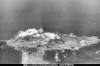 |
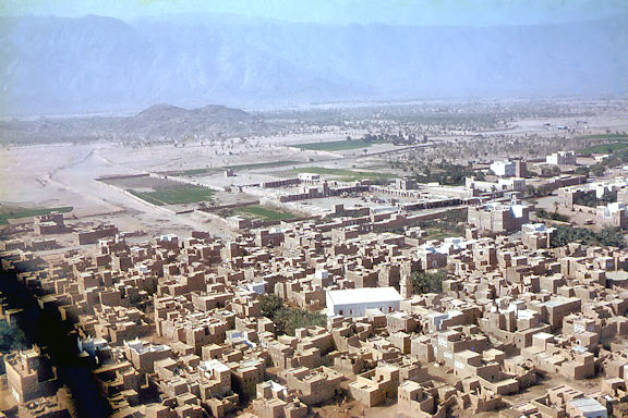
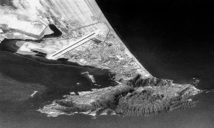
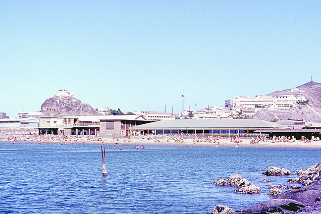
An aerial view of
Aden Colony looking south taken from the nose camera of a 1417 Flt FR.10 by
Richard Johns in 1965. The town of Crater can be seen inside the
cone of Jebel Shamsan, an extinct volcano, while Maalla (left) and
Steamer Point fan out from the shoreline facing the camera. (Roger Wilkins) |
 |
Another view of Aden Colony
looking north. This photograph was taken from above the Indian Ocean
using one of Roger Pyrah’s 1417
Flt FR.10 Vinten cameras in 1964. The narrow neck of the Peninsular
is clearly visible as is Mount Shamsan and the main runway at RAF
Khormaksar. (Roger Pyrah) |
The oldest
settlement is Crater, once Aden’s harbour and still the principal
business area, which is on the opposite side of the
peninsula from the present port. It is reached from Steamer Point or Tawahi, the
two suburbs, so merged as to be indistinguishable, which are adjacent to the
main anchorage, by a drive along the coast, through the Maala strip, where much
recent building development has been carried out on land reclaimed with spoil
dredged from the harbour, and the high gorge of the Main Pass. Two other suburbs
should be mentioned – Khormaksar, the airport and also a large RAF station, and
Sheikh Othman, a township a few miles inland, more Arab and less cosmopolitan in
character and an oasis famed for its gardens. There is also the new and
impressive Al Ittihad, on the road to Little Aden, specially built as the
headquarters of the Federal Government.
The Protectorate
Al Ittihad is connected not with
Aden Colony but with the Protectorate, a much larger area that stretches from
the Straits of Bab-el-Mandeb a hundred miles west of Aden to the borders of Muscat and Oman on
the East. Its 112,000 square miles of rocky and sandy wilderness, with few
towns, are thinly settled by a population of 650,000.
The Protectorate, which, for
administrative reasons, is divided into Eastern and Western Protectorates, came
into being as a result of a series of treaties made in the 19th
century between Great Britain and the rulers of the states surrounding Aden. These rulers were anxious to preserve their independence against the
Yemen and, later, against the Turks occupying
the Yemen, and undertook not to enter into relations with any other foreign
power if the British Crown extended its protection. In other words, Britain was
under an obligation to defend these states against external attack. Much later,
in the 1930s, further agreements between the rulers and the British Government
gave the Governor of Aden advisory powers in matters of welfare and development
in the various states. There is, however, no direct British administration of
the Protectorates – the various States, large and small, composing them are
governed by their own rulers with the aid of a British advisory staff.
The Federation
In 1959 certain of
the states of the Western Protectorate joined together to form the Federation of
Arab Amirates of the South, which now has 10 member states. Their object was to
further their political and economic progress, and the Federal Government, with
the continued financial and technical assistance of Britain, is taking over many
of the services formerly run by the Protectorate Government.
It was originally the
need to defend the Protectorate that caused Britain to establish and maintain a
military base at Aden, a base that has remained, whether garrisoned by Army, RAF
or both, and has recently been considerably enlarged in strength and scope.
There is a locally recruited military force, the Aden Protectorate Levies, under
British and Arab officers, but they are not adequate to the task of defending
the whole Protectorate, while the Government and Tribal Guards are purely
internal security forces. For, although Turkey relinquished the Yemen after the
First World War, the threat from the north continued, and independent Yemen lay
claim to the states of the Protectorate. These states were under Yemeni rule in
the 17th century, after the Arabs of south-west Arabia had united
under the Imam of Sana to throw off Turkish domination, but they revolted and
won their independence early in the 18th
century. The rulers of the
Yemen are Zeidis, a Shiah sect, while
the Protectorate Arabs are Shafeis, belonging to the opposed, Sunni, division of
Islam.
Yemeni attacks and
incursions into the Protectorate followed quickly upon the end of the war, but
an Anglo-Yemeni treaty in 1934 stabilised the frontier as it existed at that
date. This treaty remains in force until 1974, but after the Second World War
border infringements and interference in the internal affairs of the states took
place, Yemen delegates asserted their claims in the United Nations, and
relations remain strained.
The People of Aden
While the people of
the Protectorate are almost all Arabs, the Colony has a more cosmopolitan
population. At the last census, held in 1955, there were 36,910 Aden Arabs,
18,991 Protectorate Arabs, 48,088 Yemenis, 15,817 Indians, 10,611 Somalis, 3,763
Britons, 721 other Europeans and 831 Jews, while the 2,608
“others” included Palestineans,
Syrians, Lebanese, other Arabs and Americans.
Religion, in the
Colony, as in the Protectorate, is predominantly Muslim, and Muslim fasts and
festivals are carefully observed. The custom of purdah is carefully preserved by
the Arabs, and Arab women are never seen in public without all-enveloping black
cloaks and veils, though many wear smart and stylish Western clothes in the
privacy of their homes or at all-feminine social occasions. There is
considerable prejudice against European women wearing suntops, shorts or
trousers in the streets.
Shops and Bazaars
Agriculture is the
principal activity in the Protectorate, cotton being the only export of
importance, though vegetables, fruit, poultry and eggs are supplied to the
Colony. The Colony exists by commerce – its trade is mainly transhipment and
entrepot, the port being a centre of distribution for the neighbouring
territories. There is a steady trade in luxury items sold to visitors from the
ships.
The streets and shops
present a very colourful and photogenic scene to the tourist, particularly to
those who visit the bazaars.
“Window-dressing” is unknown, and
all the shops look alike with their narrow, open fronts half-screened by blinds
or a hanging assortment of merchandise. Venture inside and there is an
Aladdin’s cave of jumbled wares – cameras, transistor radios, thermos flasks,
perfume, cheap Hong Kong silk blouses, tape-recorders, wax flowers, men’s
shirts, shoes, watches, electric razors, cosmetics and quality knitwear seem to
form the mingled stock-in-trade of every shop. A number of pedlars still ply
their wares in the street – the water seller, with his buckets and a few cheap
tumblers; the hawker of nuts and lentils; the perfume merchant, with his case of
bottles and phials and sandalwood who will mix a genuine perfume of Araby to
your own instructions; the toy stalls, tucked into corners of steps and often
minded by children, and even the letter-writers, camped on the pavement with
chair, table and portable typewriter to serve those who cannot write.
To the tourist, so
long as he has some idea of what it has to offer beyond the waterfront shops and
the stereotyped and uninformed tours suggested by taxi-drivers, Aden should be a
fascinating pause in his journeying.
A selection from SAC Ronnie Hush
An airframe mechanic,
Ronnie Hush was posted out to Aden in August 1959 and served his two-year tour
on 8 Squadron towards the end of Venom operations and beginning of the
Hunter era.
|
|
|
|
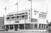
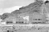
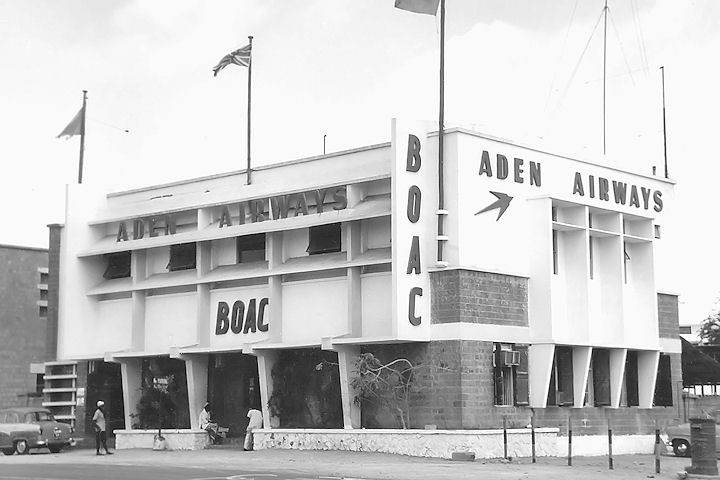
The Aden Airways Terminal building at Khormaksar in 1960 (Ronnie Hush)
|
|

|
|
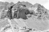
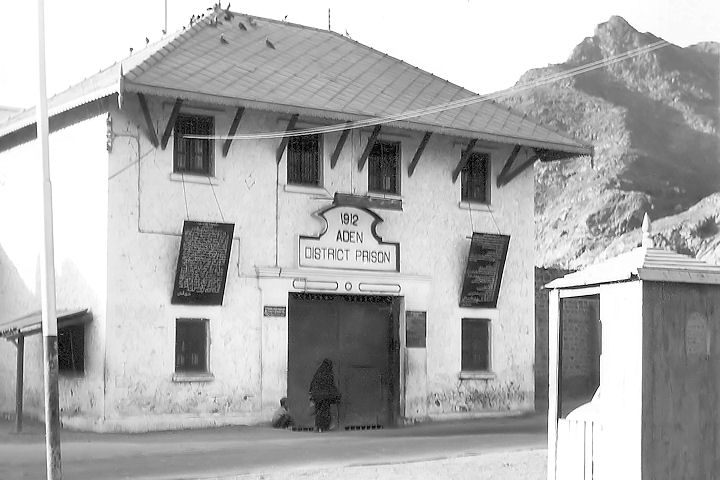
A place to be avoided at all costs - Aden Prison in Crater in 1960 (Ronnie Hush)
|
|
|
|
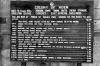
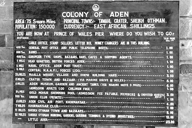
A free port, Aden was a popular stopping off point for cruise ships and this information board was an invaluable aid for passengers (Ronnie Hush)
The board was located by the Prince of Wales Pier |
|
|
|
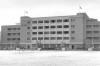
Located not far from Aden harbour at at the southern end of Maala Straight was the P&O administration building (Ronnie Hush)
|
|
|
|
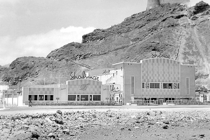
Popular off-site entertainment venues, the Shenaz Cinema and Shalimar Restaurant, located at the junction for Little Aden and Crater (Ronnie Hush)
|
|
|
|
|
|
A view of the top of the Tawahi Water Tanks situated at the base of Shamsan mountain above Crater (Ronnie Hush)
|
|

|
|
One of the most detested creatures in Aden, a Kite Hawk (or Shitehawk) is posed for the camera at Tawahi Tanks by a local arab (Ronnie Hush)
|
|
|
|
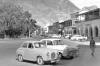
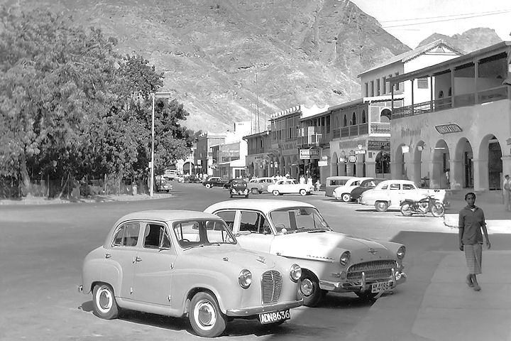
The Crescent in early 1960 depicting various classic cars of that era (Ronnie Hush)
In the park behind the trees on the left stood the statue of Queen Victoria and one of the favourite cries of the locals was "Queen Victoria very fine man, Chelsea for the Cup". |
|
|
|
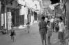
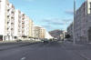
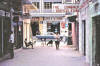
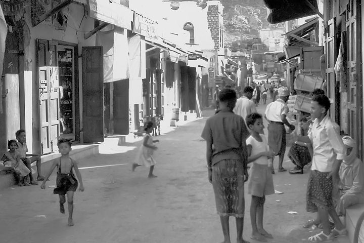
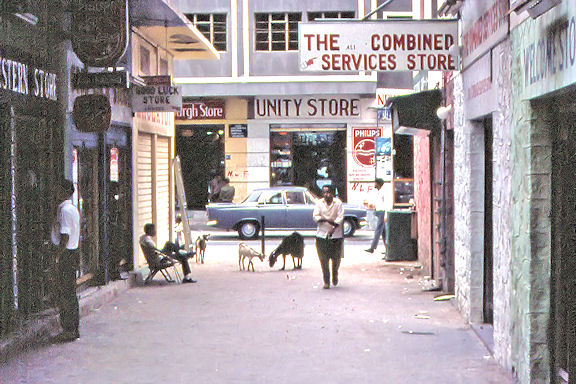
A typical back street off the Crescent district of Aden in early 1960 (Ronnie Hush)
|
|
|
SAC Malcolm Stelfox collection
The following images of Aden and the local population were contributed by
Malcolm who served as a Telegraphist in the Khormaksar Control Tower in 1966/7.
He also recalls that: “Tawahi was the main port and shopping centre with
The Crescent forming an arc around east side of Victoria Gardens complete
with a statue of Queen Victoria. Continuing south, you passed the main pier
with Little Ben standing on a promontory overlooking the harbour, then
followed the road up to Steamer Point. The latter could be reached by taking
an Aden Bus Co (civilian) bus from Khormaksar running via Maala and
Tawahi. Access to Steamer was up an old narrow gauge railway track that
ended in a small roundabout where the bus turned round. That part of the
peninsular was tightly secure allowing us to spend off duty time swimming,
waterskiing and sunbathing on the Maidan Club beach. To say Aden was a
female-free posting was not strictly true as, apart from the WRAF at HQ MEC,
there were daughters visiting their families every holiday on the ‘lollipop’
specials.
In July 1967 I managed to get a couple of weeks
‘LUKFREE’ back home and when I returned at the beginning of August the RAF
were consolidating within the Khormaksar airfield boundary and abandoning
Steamer Point. That was the point at which it started to get really tough as
all the usual leisure activities were being shut down. In addition to that,
the local Arabs workers were being intimidated into not working for the
British and Khormaksar relied heavily on local labour. When our section shut
down at the end of September, instead of hanging around for weeks waiting
for a flight home, I managed to transfer to the VASF to help the night shift
loading Belfasts and Britannias with equipment being returned to the UK.
Needless to say, in the nature of things most VASF staff had already been
sent home just as they were about to get really busy. Another admin muddle!”
|
|
|
|
Maala Straight was lined with blocks of flats built on reclaimed land in the early 1960s. Most of the flats were service hirings (Malcolm Stelfox)
By the end of 1966 when there was a lot of bombings and shootings in the area, service families were virtually under siege. |
|
|
|
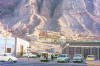
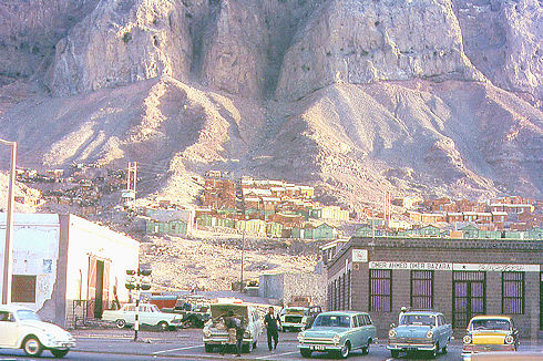
Clamped precariously to the craggy base of Shamsan Mountain and overlooking Maala district, was this delapidated shanty town (Malcolm Stelfox)
|
|
|
|
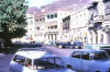
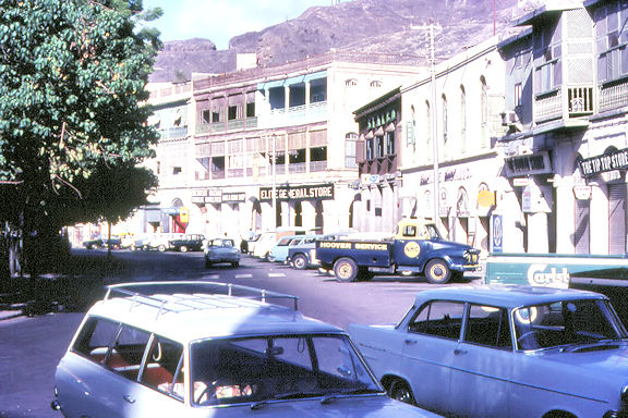
The Crescent at Tawahi in 1966, heart of the main shopping district of Aden and regular destination for service personnel (Malcolm Stelfox)
|
|
|
|
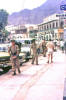
As a result of indiscriminate shootings in the mid-1960s, army patrols provided increased security in places such as The Crescent (Malcolm Stelfox)
The soldier in the photograph is dressed in what was bog standard kit for all infantrymen - they never wore shorts and rarely tin hats. The radio speaks for itself - underpowered, cumbersome and heavy. |
|
|
|
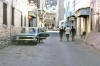
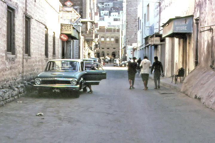
Behind The Crescent lay numerous narrow back streets and tiny shops selling cheap duty free goods (Malcolm Stelfox)
|
|
|
|
|
|
Another view of the back streets behind The Crescent in 1966 (Malcolm Stelfox)
|
|
|
|
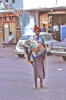
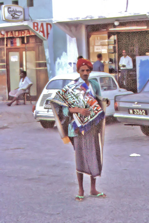
Goods could also be purchased from nomads who wandered the back streets, this shot of a carpet 'salesman' being a prime example (Malcolm Stelfox)
|
|

|
|
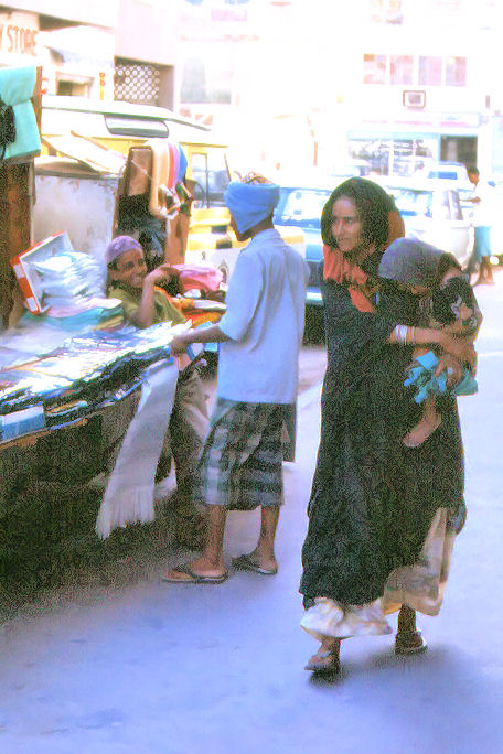
An Arab woman carrying her young child walks passed a couple of traders selling their wares in a Tawahi back street in 1966 (Malcolm Stelfox)
|
|
|
|
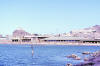
The Steamer Point Beach Club, seen in this 1966 view, was a popular venue for relaxing with friends and family (Malcolm Stelfox)
The buildings in the background were all part of HQ MEC at RAF Steamer Point. |
|
|
|
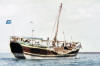
An Arab Dhow slowly phutt-phutts its way out of Aden Harbour before raising its sail for another day's fishing at sea (Malcolm Stelfox)
|
|
|
|
|
|
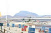
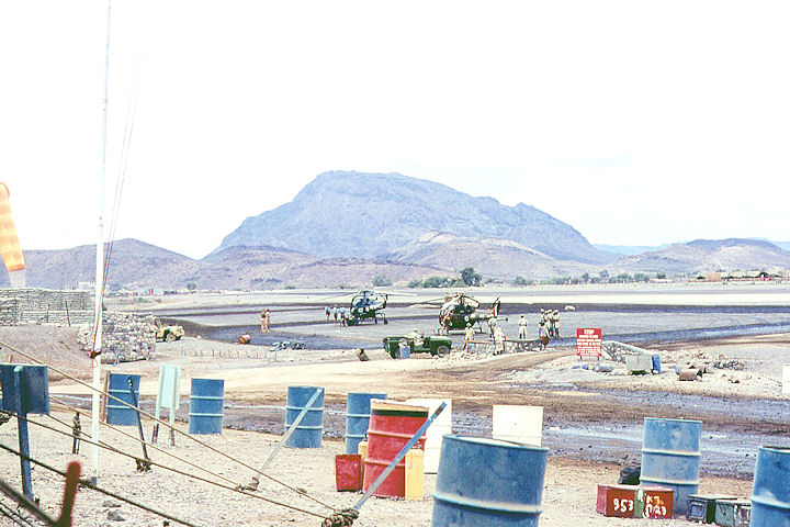
Habilayn in 1966, a hostile and exposed airfield high up in the mountains by the Yemen border. The helicopters are RN and AAC Wasps (Malcolm Stelfox)
Of note are the FRA troops around the nearest chopper.
|
|
|
|
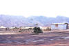
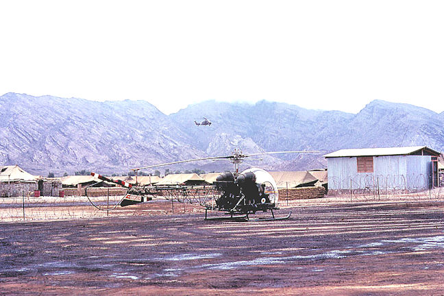
A 78 Sqn Wessex arriving at Habilayn with AAC Sioux in foreground. The low cloud base was a hazard to Hunters flying in the area (Malcolm Stelfox)
Habilayn was originally known as Thumier but was renamed during the subsequent Radfan conflict |
|
.jpg)
|
|
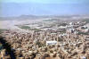
Another 1966 view of an AAC Sioux at Habilayn with army vehicles typical of the sort used up in the mountains lined up behind. (Malcolm Stelfox)
Of interest is the oil-doused sand in the foreground, the method used to keep dust to a minimum. |
|
|
Cpl Tim Gibb's collection
Cpl. Tim Gibb, R.E.M.E. was attached to 653 Sqn, 13th Flt.
Army Air Corps, when he was killed in action on 5 May 1967, when an army
helicopter in which he was flying, crashed into a hillside and burst into
flames. A selection of his photographs from that era was kindly contributed to
the website by his colleague Robert Smith.
|
|
|
|
The town of Beihan as seen from an AAC Sioux helicopter on the approach to the airfield (Tim Gibb)
|
|

|
|
Beihan town lay in the shadow of the surrounding mountains. In this view, the town's open air cinema can be clearly seen
|
|
|
|
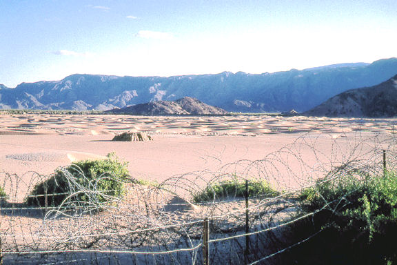
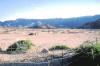
Looking out across a hot desert from Beihan Camp to the mountains beyond (Tim Gibb)
|
|

|
|
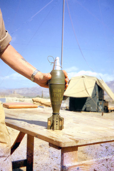
British 81m mortar bomb captured at Habilayn camp. (Tim Gibb)
Ironically, many of the mines and bombs used against British troops in Aden were identified as coming from the British stockpile at Tel el Kiebir armoury, taken over by the Egyptian army after the withdrawl from Suez in 1956. |
|
|
|
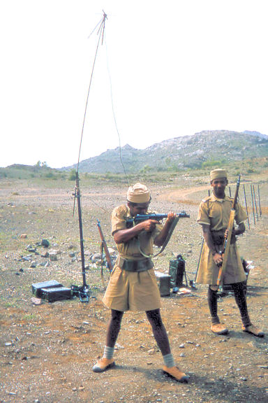
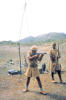
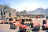
Two FRA soldiers pose for the camera at Dhala (Tim Gibb)
|
|
|
|
|
|
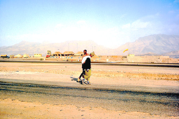
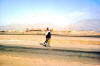
A couple of locals walking beside the Habilayn airstrip (Tim Gibb)
|
|
|
|
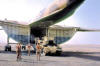
Loading a Royal Tank Regiment Saladin into 84 Sqn Beverley, XL149 (Tim Gibb)
|
|
|
|
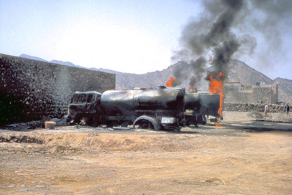
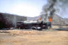
One of three views of a terrorist attack on a small FRA fort in the Dhala area (Tim Gibb)
|
|

|
|
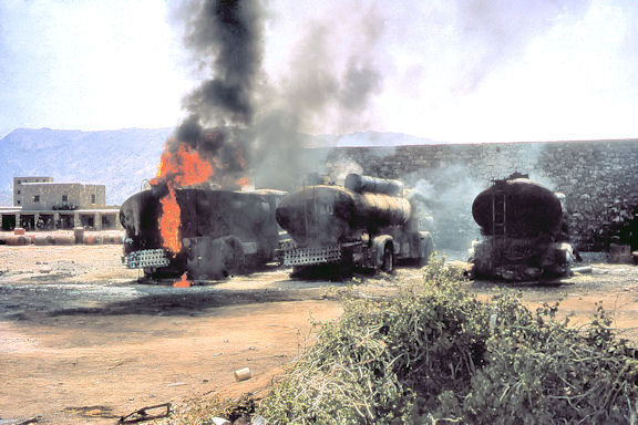
Second of three views of a terrorist attack on a small FRA fort in the Dhala area (Tim Gibb)
|
|
|
|
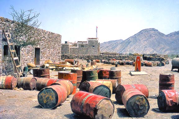
Third of three views of a terrorist attack on a small FRA fort in the Dhala area (Tim Gibb)
|
|
|


.jpg)